
Hopewell Arch Out and Back with Detailed Navigation
/
Overview. Hopewell Arch is the most beautiful arch I’ve seen so far in Red River Gorge. While I’ve published trail navigation before, I took some extra time to put together detailed directions for this out and back. The reason is simple - when hikers don’t have marked trails, a zoo of trails invariably forms. These zoos detract from the hiking experience, damage vegetation and habitat, and generally turn what could be a beautiful forest walk into a trashy network of dirt. So, please take care to follow the trail and download an offline copy of this post in Chrome by tapping the download button. Alternatively, print a copy of this page to .pdf and save it to your device before you reach the trailhead.
Route Type | Out and Back
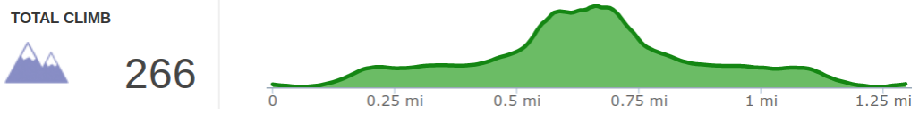
Total Distance | 1.25 miles
Overall Difficulty | Moderate to Strenuous
*this hike is unmarked and is best for seasoned off-trail hikers
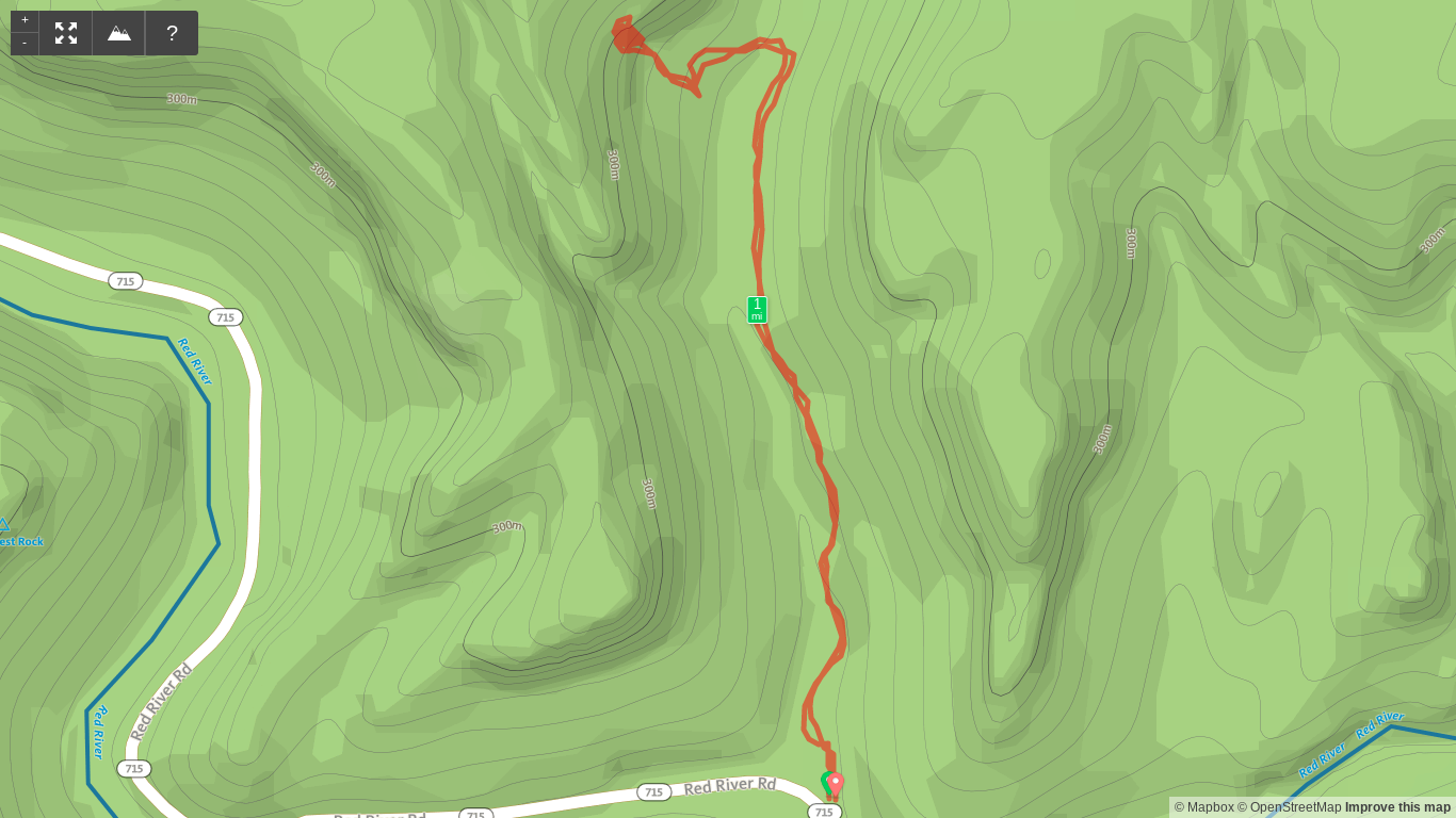
GPS Waypoints
Turnoff to Hopewell Arch | 37.826361, -83.576556
Pick-up Trail West of Creek | 37.826800, -83.575894
Sharp Turn Up Old Road | 37.826606, -83.576853
Move Left of Split Rock | 37.826972, -83.577558
Hopewell Arch | 37.827139, -83.577722
Trailhead. Park at the Osborne Bend Parking Lot or other designated parking pull-offs on KY-715 just west of the one lane concrete bridge. [map]
Trail navigation. This hike begins from the Copperas Creek parking area just west of the Osborne Bend lot. Take either of the pathways and begin moving uphill until reaching a false top with a truly gigantic boulder to the left of the trail. Just beyond this is a drainage that you’ll descend to reach the creek bed. Across the creek, find a small boulder with a well trod trail to the right that moves uphill behind it. Continue on this path until reaching an old roadbed and turn left (south). The trail ahead will appear to be blocked, but there is a path beyond the vegetation. Cross the small drainage and travel a short distance to find some branches that have been placed to obstruct the trail. This is your marker to make a sharp right to continue your climb. The trail here is well traveled and firm underfoot. If it feels soft, you’re off the trail and should turnaround to regain the firm trail. Move uphill to find a cracked rock. Move left around the rock and follow the trail around it before seeing a log leaning against the cliff face. Make your way to the cliff face and follow it around until you reach some rocks that you’ll need to climb to reach the arch. There is an option just before reaching the plateau underneath the arch to go around, but be careful here to not hit your head and lose your balance. Alternatively, you can lift yourself up on some rocks to reach the plateau.
CAUTION - Poisonous snakes. While the gorge is within the range of timber rattlesnakes, copperheads are the most common poisonous snake encountered. Stay alert on the trail, as snakes are commonly found taking in the warmth of the trail. Give them a wide berth or wait for them to move off the trail.
CAUTION - Bears. Black bears are growing in number throughout Daniel Boone National Forest. Be sure to follow bear safety precautions. [Be Bear Aware by US Forest Service]
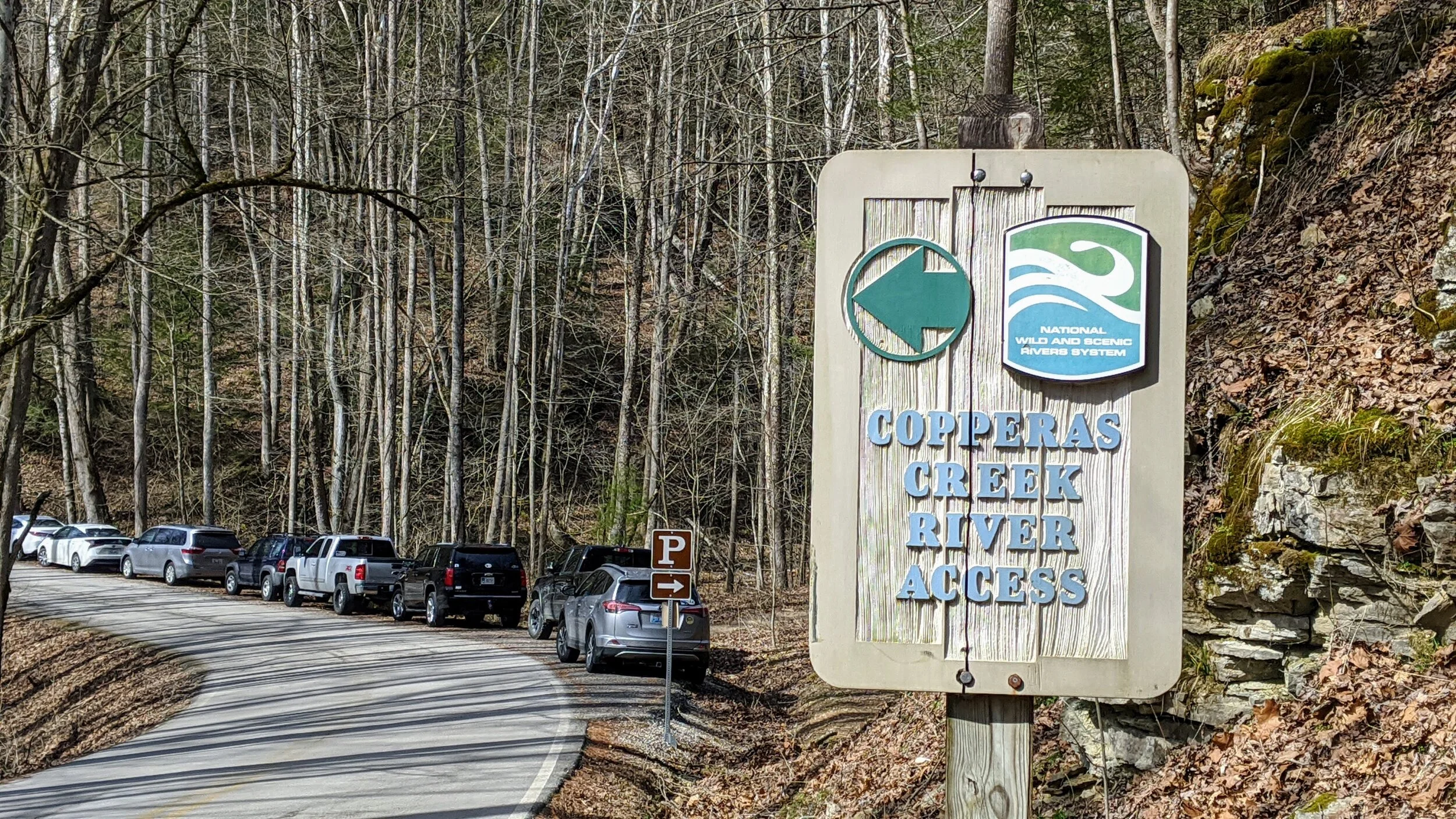
Roadside pull-off parking next to Copperas Creek Trailhead.

Massive boulder to the west of Copperas Creek Trail before reaching false top and turnoff to Hopewell Arch.

Looking down to the small boulder that marks the beginning of the spur to Hopewell Arch.

Closer view of small boulder and distinct trail to the right (north) of the boulder. Follow this around and up the hillside.

False end of the trail to Hopewell Arch. Continue through the narrower trail and cross the drainage.

Logs marking the sharp turn to continue on the trail to Hopewell Arch.

A look at the sharp turn to continue up to Hopewell Arch.

Split rock on the trail to Hopwell Arch. Move left around the rocks to stay on trail.

Downed tree leaning against the cliffline. Hug the cliffline and continue around to the right to reach Hopewell Arch.

The last bit to gain this plateau is your choice. Circle around on the dirt trail or lift yourself up on the rocks. Be careful to if taking the dirt option to avoid hitting your head on rock, losing your balance, and taking an ugly fall.